New maps detail routes to tsunami safety for Coastal Washington
New maps have been created for the Twin Harbors coast that shows routes to tsunami safety in case of an emergency.
The maps were created as part of the Washington State Department of Natural Resources (DNR) efforts to provide tsunami safety information to communities along Washington’s coast.
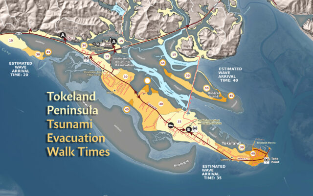
Geologists modeled and published the maps showing the estimated time to walk to safety in the event of a tsunami produced by a major earthquake on the Cascadia subduction zone.
In addition to Tokeland Peninsula maps, DNR also released new evacuation time maps for North Ocean Shores and Grayland.
Knowing where to walk and how long it might take to get there could be one of the most important pieces of information for anyone in coastal communities when a tsunami strikes.
Construction of a vertical evacuation structure by the Shoalwater Bay Indian Tribe has made it easier for people on the 3-mile long Tokeland Peninsula to get to safety when the next tsunami washes ashore.
“It’s critical our coastal communities know what to do and where to go before the next tsunami hits,” said Commissioner of Public Lands Hilary Franz. “I’m incredibly thankful the Shoalwater Bay Tribe’s commitment to making everyone on the Tokeland Peninsula safer, providing people a refuge when they need it. The Auntie Lee Evacuation Tower will save lives, and I hope it serves as a model for other communities along the coast where our geologist have found there isn’t enough time to walk to safety when – not if – the next tsunami arrives.”
On the Tokeland Peninsula, the construction of the Auntie Lee Vertical Evacuation Tower reduced what was a 90-minute walk to as little as 15 minutes.
According to DNR models, waves from a tsunami produced by a magnitude 9 earthquake on the Cascadia subduction zone would be approximately 17 feet high and arrive approximately 35 minutes after the earthquake.
On August 5th, the Shoalwater Bay Indian Tribe dedicated the Auntie Lee Vertical Evacuation Tower.
The tower is the third vertical evacuation structure in North America, joining rooftop structures in Westport, Washington and Newport, Oregon, and can accommodate over 400 people.
Using models of a magnitude 9 Cascadia earthquake, the maps use colors to indicate how many minutes it would take to walk to safety at a moderate pace within these communities.
These maps can help communities prepare and plan for a tsunami evacuation. They also highlight where evacuation challenges exist, such as locations of probable bridge failures and areas in need of evacuation structures where no high ground is available. The maps were made in coordination with local emergency managers.
Waves from a Cascadia earthquake-induced tsunami could reach some coastal communities in as soon as 15 minutes after the next megathrust earthquake starts. The last Cascadia rupture was 322 years ago.
Models, maps available online
The new pedestrian maps and maps for other communities are available through an interactive map on the DNR web site: https://www.dnr.wa.gov/programs-and-services/geology/geologic-hazards/tsunamis#tsunami-evacuation-maps
The interactive map also provides access to tsunami evacuation brochures for areas that do not have walk time maps yet.
Other information about impacts from earthquakes to Washington communities is available on DNR’s Geologic Information Portal at: https://geologyportal.dnr.wa.gov