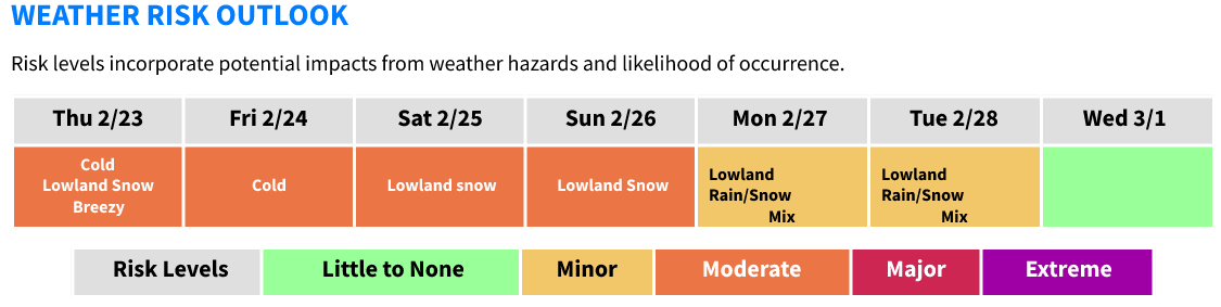
Winter weather to bring snow to lowland areas

The National Weather Service says that areas of lowland snow will linger across the Olympic Peninsula, WA Coast, and south of Puget Sound through Thursday morning, resulting in up to 3 inches of new snow accumulation.
Very cold temperatures are expected through the rest of the week, with low temperatures in the 20s and high temperatures in the 30s.
This weather outlook is an update to previous reports with a higher probability of accumulating snowfall over the majority of the lowlands late Saturday into Sunday.
Cold temperatures will remain set in place through the end of the week, with a slow modifying trend through the weekend.
The next weather system set to arrive Saturday-Sunday likely to feature lowland snow at the onset before transitioning to a rain/snow mix.
Tonight
Cold temperatures with lingering lowland snow showers, especially west and south of Puget Sound Areas of minor snow accumulation possible, especially along the Northern Olympic Peninsula, the WA Coast, and south of Puget Sound
Breezy to locally gusty winds will continue across Western Whatcom County and the San Juan Islands tonight as Fraser outflow strengthens
Breezy east winds also likely to develop across the East Puget Sound lowlands
Thursday-Friday Night
Cold area-wide with drier conditions
Morning temperatures in the teens to low 20s
Winds chills in the single digits to near zero likely across Western Whatcom County during the morning hours both Thursday and Friday. Winds chills in the single digits across the East Puget Sound Lowlands Thursday
morning.
Snow showers will linger across the Olympic Peninsula, south of Puget Sound, and WA Coast through Thursday morning with minor accumulations (less than 1 inch) possible
High temperatures in the mid to upper 30s (low 30s more likely in Western Whatcom County)
Saturday-Early Next Week
Another system will bring a return to wet conditions later in the day Saturday and through Sunday, followed by another system Sunday night into Monday
Precipitation is likely to begin as snow or a rain/snow mix late Saturday through Sunday morning, with accumulation possible (generally less than 2 inches)
Breezy conditions may accompany this system.
Another system will likely follow on the heels of this mid-weekend system, which could result in a transition back to rain/snow Sunday night into Monday
Temperatures will moderate during this time period, with highs in the 40s and lows in the low to mid 30s