The National Weather Service says that periods of lowland snow are possible late Saturday night through next week.
While the possibility of snow is primarily being forecast outside Grays Harbor, the region will see weather conditions that could bring some lowland snow.
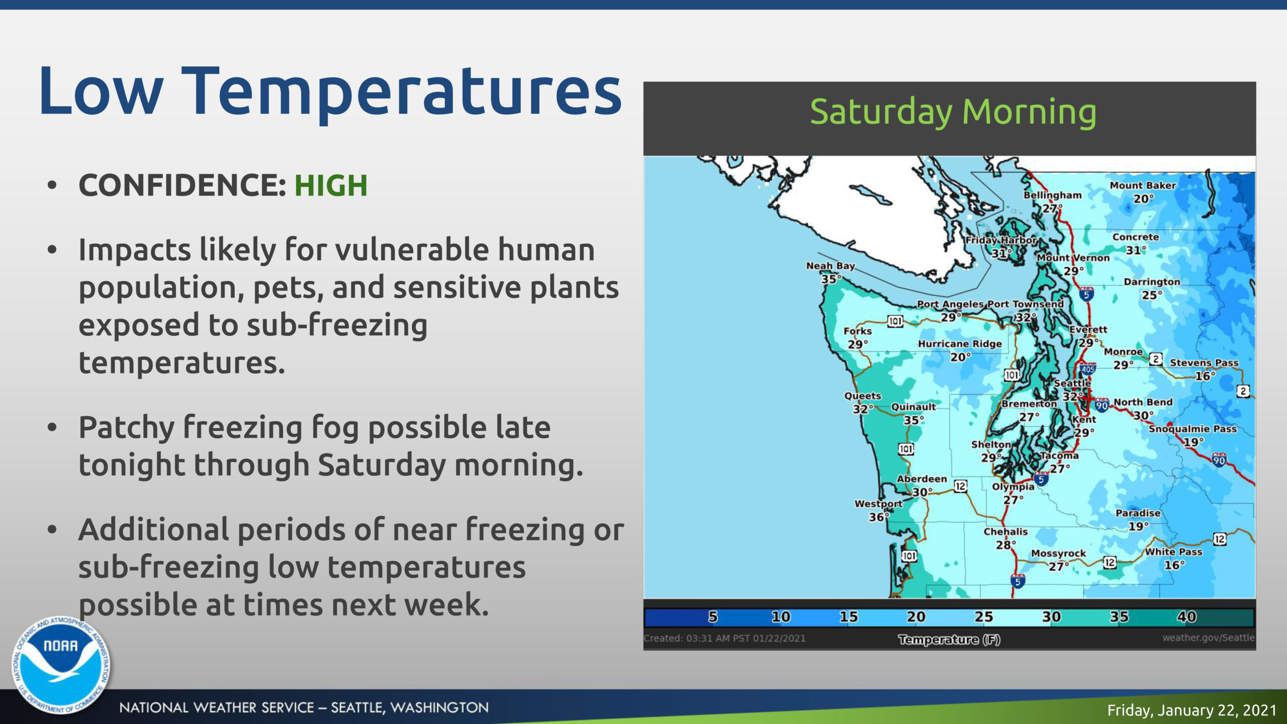
Sub-freezing temperatures are expected tonight through Saturday morning, with patchy freezing fog possible.
Cooler temperatures and low snow levels will persist through much of the week.
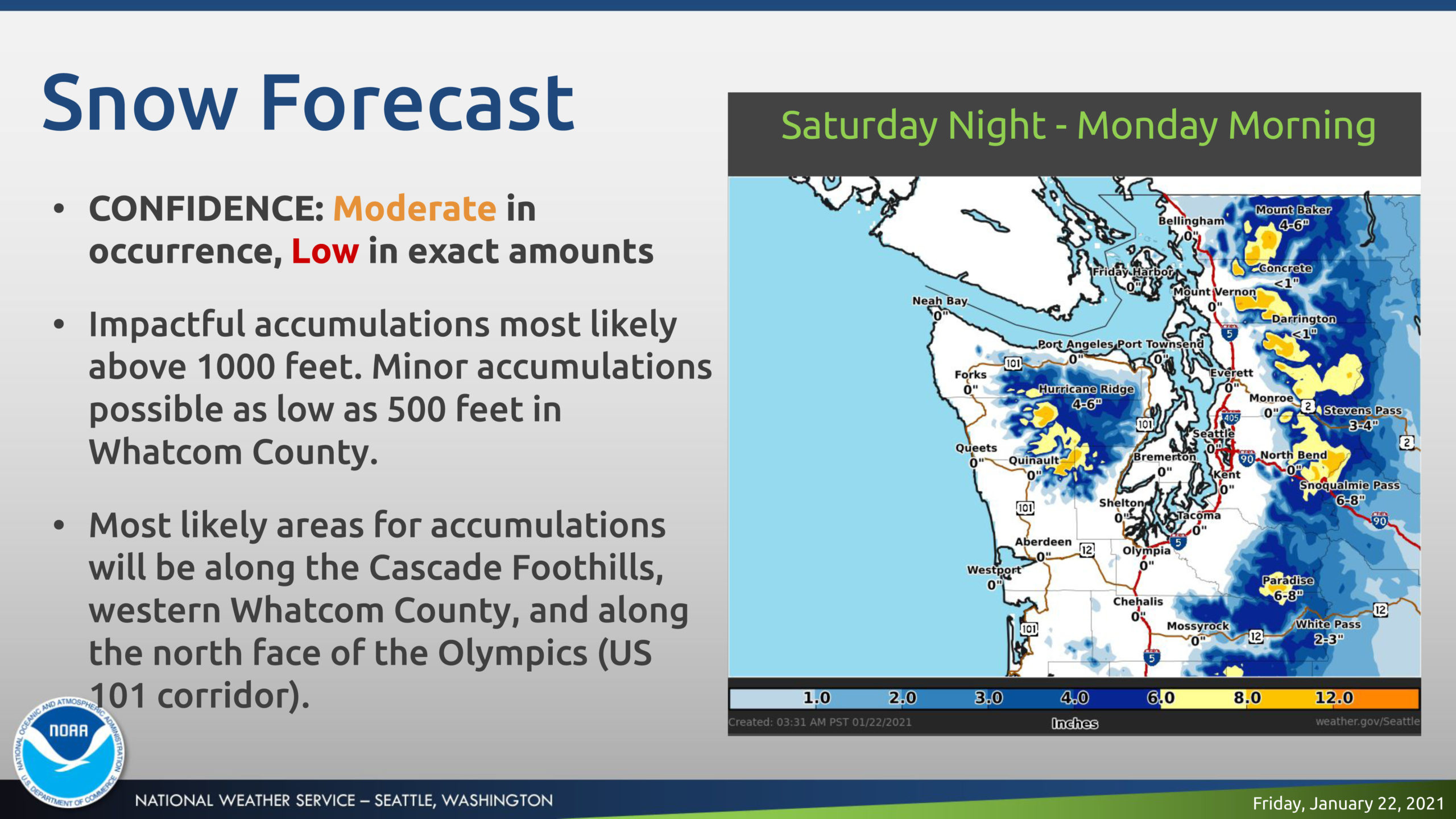
Two separate systems will produce chances for lowland snow Saturday night through early Monday and again Tuesday night through Thursday.
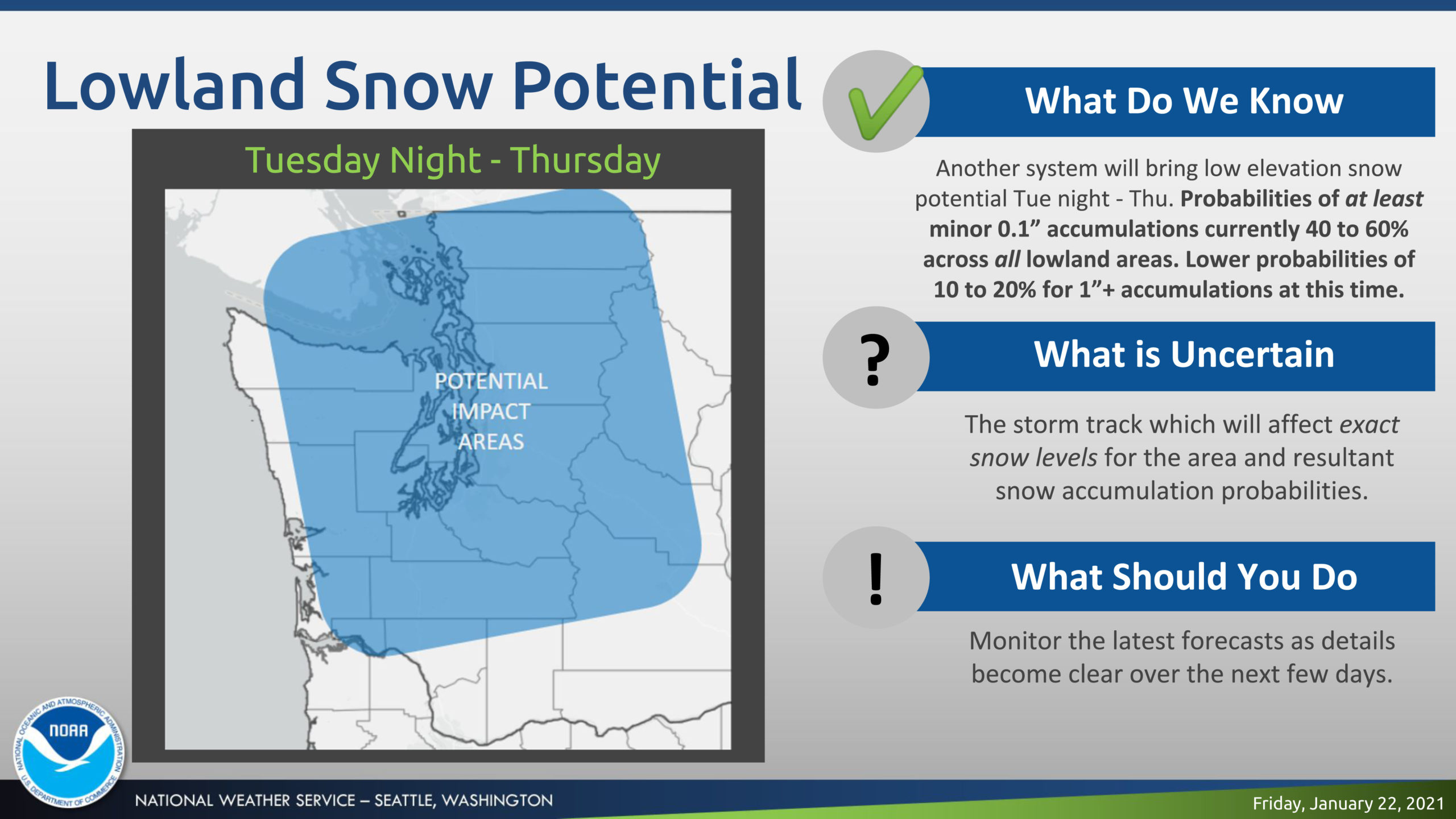
Officials say the highest probabilities for at least minor accumulations across all of the lowlands currently are expected Tuesday night through Thursday.
WEATHER AND IMPACT OUTLOOK
| Fri 01/22 |
Sat 01/23 |
Sun 01/24 |
Mon 01/25 |
Tue 01/26 |
Wed 01/27 |
Thu 01/28 |
| Sub-freezing temperatures (late), Patchy
Freezing Fog (late) |
Sub-freezing temperatures (AM), Patchy
Freezing Fog (AM) |
Lowland Snow |
Lowland Snow early (ending) |
Lowland Snow late |
|
Lowland Snow Lowland Snow |
CONFIDENCE AND DETAILS
|
Western Washington
|
| HIGH Confidence |
- Sub-Freezing Temperatures Fri Night – Sat Morning: Impacts to vulnerable human population, pets and sensitive plants exposed to cold temperatures for periods of time.
|
| MODERATE Confidence |
- Cooler Temperatures With Low Snow Levels: Lowland snow is possible late Saturday night through at least Thursday across the lowlands due to low snow levels and cool temperatures near the surface, which may impact travel at times.
- Freezing Fog Fri Night – Sat Morning: Patchy freezing fog could cause travel impacts, including slick roadways and elevated surfaces, mainly from the south Sound/Hood Canal south through the Chehalis Valley.
|
| LOW Confidence |
- Exact Snowfall Totals: Snowfall totals look generally light and under 1″ for most areas Sunday – Monday. Higher elevation communities closer to the Cascades could see 1 to 2″ accumulations and travel impacts. Higher probabilities of snow accumulation below 500 feet midweek could introduce travel impacts for lowland areas.
|
| Forecast Details |
- Tonight through Saturday Morning
-
- Overnight/morning temperatures below freezing in the upper 20s to low 30s.
- Freezing fog is possible, especially in the Hood Canal region southward through the Chehalis Valley. Elevated surfaces and less traveled side roads most susceptible to freezing.
- Saturday Night through Monday
-
-
- Overnight/morning temperatures near freezing in the lower 30s; highs in the lower 40s.
- Snow levels hovering around 500-1000 feet early, rising to 1000-1500 feet Sunday with the lowest levels across Whatcom County.
- A mix of rain and snow possible across the lowlands. Highest probabilities for any accumulation across the Cascade foothills, western Whatcom County and areas along the northern face of the Olympics.
- Tuesday through Thursday
-
-
- Another system expected to move across Western Washington Tuesday night – early Thursday with low snow levels remaining in place.
- Snow levels generally below 500 feet Tuesday night – Wednesday morning, rising to 500 to 1000 feet Wednesday afternoon.
- Current probabilities for at least minor accumulations currently at 40 to 60% across all lowland areas below 500 feet.
- Current probabilities for 1+ inches of accumulation at 10 to 20% across lowland areas.
- Higher accumulations possible in the Cascade and Olympic foothills, with 30 to 40% probabilities of 1″+ and around 20% of 2″+ accumulations.
- Friday
-
- Warming temperatures, and rising snow levels (2000-3000 feet) and rain across the lowlands.
|
For the latest forecast updates, visit www.weather.gov/seattle.
If you have questions or would like to submit weather reports, photos, or to unsubscribe from these briefings, email [email protected].